We are rolling out a new 9th grade course next year titled Geographic Cultural Studies, which is intended to cover some curriculum gaps we’ve noticed in current 9th graders and offer students a more relevant course than a non-AP version of Human Geography. Although geography will the primary focus, each unit covering a specific geographic area of the world, it will also be interdisciplinary. I am excited about developing and teaching it next year.
Teaching a new course always offers challenges, and the final product is usually a little different from the plan going into the year. I expect there to be some changes to both the content and skill standards after having spent a year teaching and developing it. However, several of the C3 geography standards have been prioritized to guide the course through its first year.
The C3 geography standards are a little different than those for history. While the history standards are very clearly skill-based, the geography standards seem a bit more rooted in content. This presents a challenge when developing proficiency scales. I spent some time trying to interpret the spirit of each standard to better unpack them and determine where standards can be combined or connected within a single scale. The results are below. I welcome any feedback from anyone who has used these standards before or has a bit more geography experience. I expect these scales to be “living documents” as they will be edited, updated, and filled out over the course of the year. This will in turn help produce clearer “student friendly” versions. The process of teaching a standard always offers new insights to its meaning, intricacies, and application.
The images below are of the main portion of the scale, but are incomplete. There is a link to a word/google doc that includes the full proficiency scale. I have not written a scale for every C3 geography standard, just the ones we have prioritized thus far. Maybe at some point in the future I’ll have a complete page with proficiency scales for every C3 standard…something to try for at least.
A note on vocabulary. Seasoned teachers may find the vocabulary sections of these scales incomplete. They are not intended to capture the content specific words which will be taught based on the illustrative examples chosen. Instead, I just put together a short list of “skill” vocabulary terms to guide the direction of instruction. These lists will be filled out more in the future.
Standard 3
D2.Geo.3.9-12. Use geographic data to analyze variations in the spatial patterns of cultural and environmental characteristics at multiple scales.
This standard seemed the most significant of standards 1-3 which were all part of the same “Spatial Views of the World” strand. We will use this standard to teach all the various mapping skills that need to be taught and assessed. Our students are in dire need of basic geographic knowledge, and each unit’s map test on both physical features and state boundaries will be an important part of the score 2.0 knowledge. The analytical depth will be how that knowledge is applied to understand a region and its cultural and environmental characteristics.

Standard 4
D2.Geo.4.9-12. Analyze relationships and interactions within and between human and physical systems to explain reciprocal influences that occur among them.
The term “human systems” needs some interpretation. I chose to interpret it through a historical lens since each of our units will be embedded with historical examples that show insight on the contemporary world. I also saw the determinism vs. possibilism debate fitting well within this standard. After all, what geography course is complete without referencing Jared Diamond?
I think this standard will be useful in our units on Europe and China, where a focus will be the role of geography in Europe’s fracturing after the fall of Rome and China’s tendency to re-unify itself through each dynasty.

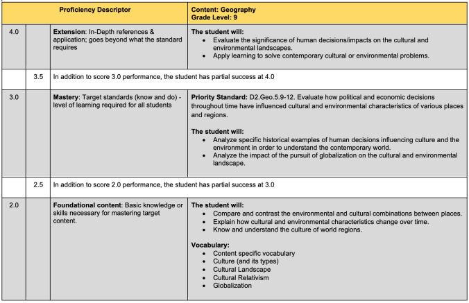
Standard 5
D2.Geo.5.9-12. Evaluate how political and economic decisions throughout time have influenced cultural and environmental characteristics of various places and regions.
This was a harder one to write because I kept finding myself wanting to focus on the history that kept coming to mind as illustrative examples of the standard. I expect this one to change the most as I begin teaching the course. At the moment, I plan to use this standard to unpack the concept of the cultural landscape and how it is influenced by various factors.
Standard 10
D2.Geo.10.9-12. Evaluate how changes in the environmental and cultural characteristics of a place or region influence spatial patterns of trade and land use.
This standard seems to address some of the content in units 6 and 7 of the AP Human Geography curriculum. Seeing that connection, as well as the knowledge that this standard will be applied to gaining an understanding of contemporary regions of the world, as led me to call this the “development” standard for the time being. It really would be helpful if organizations that wrote standards provided some sort of guidance or context on how they meant for the standard to be interpreted.

Standard 11
D2.Geo.11.9-12. Evaluate how economic globalization and the expanding use of scarce resources contribute to conflict and cooperation within and among countries.
This standard is very clearly the “globalization” standard we will use to help make economic connections, pairing it with some of the C3 economics standards. The skill and analytical aspect of this standard is clear, and I am looking forward to selecting the specific historical and contemporary examples to teach it with.

There are not as many proficiency scales available online as I expected when I started this process. I spent some time searching for geography exemplars, with only a few sticking out. Thankfully, the language and spirits of standards have a lot of overlap and ideas can be easily borrowed or reworked. A few links of other examples I found and gained insight from are linked below.
You can always buy certain sets of proficiency scales from consultants like Marzano, but I am a firm believer that taking the time to go through the process on your own is excellent professional development. It’s not a perfect proficiency scale that makes for a powerful classroom experience, its having a teacher who has thought through the curriculum and applied that insight to their planning and teaching. A curriculum can look amazing or terrible on paper, but it is only ever matches the quality of the teacher delivering it.
Portage High School – Indiana
Steilacoom School District – Do a search for “proficiency scales” and many examples will come up.